 |
| International Connectivity |
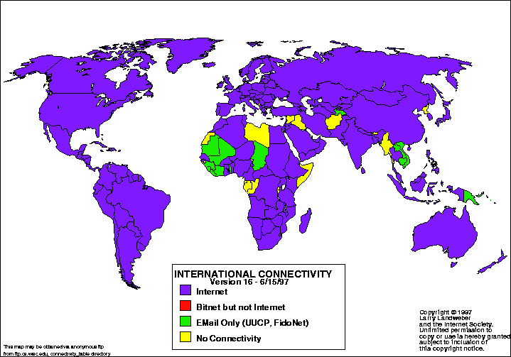
Searching for an interesting map, I found this internet connectivity map. This map was taken from the
Atlas of Cyberspaces website. Larry Landweber, from the Computer Science Department of the University of Wisconsin - Madison, created the map to conduct a "census" of internet connectivity. Done in 1997, this particular map indicates: 1. which countries are connected to the internet, 2. which have bitnet, but not internet, 3. which have email only such as UUCP and FidoNet, and 4. which have no connectivity at all. Furthermore, the colors used were purple, red, green, and yellow. However, what was not included on this world map was Antarctica. Even though it is an inhabitable place for humans, it still would have been more complete if stated whether internet connectivity was possible there. Altogether, it contained interesting information.
To find an interesting map, I searched "statistical maps" and came across this particular one. Which countries don't have internet and which do intrigued me, because I never really thought about it and I always assumed that the internet was worldwide. Living in a country that does have internet connectivity is a luxury. From this map, I can
assume that those countries that do not have full internet are the less developed nations in Africa and Asia; however, that requires further research. But in this particular case, the map was created in 1997. I wonder if the countries that didn't have internet connectivity back then, have it now in 2012.
 |
| Storms between 1900-2011 |
This map was taken from the
Stamen Design website. This map's creator is not stated on the website; however, it is also an
MSNBC Historical Map, which is interactive and is able to isolate particular storms that occurred between the years 1900-2011. This particular snapshot of the interactive map (taken from the Stamen Design website) depicts storms that had made landfall between the years mentioned. Two other options that are available are "no landfall" and "all storms" on the interactive map. Furthermore, the routes of the storms can be isolated and information such as the name of the storm can be seen. Based on its color from green to red, the storm's strength on the Saffir-Simpson Scale can be noted. From a single map, one can find various information on a single or many storms.
This map interested me because of the bright green, which are the paths of some of the storms. At first glance, it seemed like scribbles over North America and parts of the Atlantic Ocean. However, on further inspection, there is so much information on a single snapshot. The further I investigated this snapshot of the interactive map, my interest grew more and more. It is intriguing how many storms the US goes through in a matter of a hundred years. It surprised me how much information a single map can hold.
 |
| Sunken Kronprinz Wilhelm Battleship |
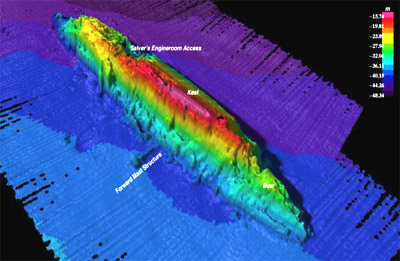
Searching ocean maps, I came across this particular one in Google images. This map was taken from a website about
GIS Day, but the maker of this map was not mentioned on this website. It is part of the Ocean Mapping and Exploration Maps Collection of GIS Day back in 2006. So, this map depicts the depths of the ocean with various colors - with the cooler colors as the deepest in the ocean. The map also labels the parts of the battleship such as the engine room access, the keel, the forward mast structure, and the bow. The keel, which is labeled as the pink area, depicts the highest point of the boat. I assume that the edges colored black are the deepest points of the map and places where reading was not or could not be done. For ocean mapping, this particular map is interesting because it is not like a conventional map.
This map intrigued me because it differed in what I usually think maps are. It hadn't occurred to me that this is a type of map. Furthermore, I am curious as to what type of instrument can make these maps. I can only think of an instrument making some sort of wave through the water to determine the depth of the ship and the sea floor. However, I am not familiar with any of it. Also, I am curious as to why the ship is positioned in that way. Why is the ship sideways and not pointing downward? This map evoked questions about the type of instrument used and why the battleship is in the position it is in and that is why this map is interesting to me.
No comments:
Post a Comment